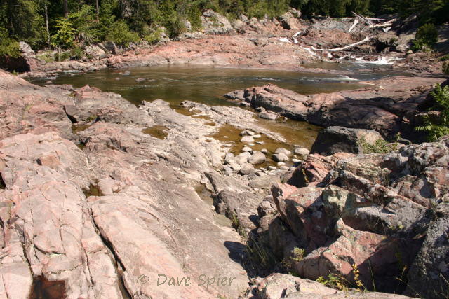
From the park overlook, you get a wide view of Ludlowville Falls. In the shade to the left (out of the picture) there is a “cave” eroded into the shale and roofed by the Tully formation caprock. (ref. # D060797) © Dave Spier
Ludlowville Falls is on Salmon Creek in the Town of Lansing on the east side of Cayuga Lake in New York’s Finger Lakes region. The height of the falls is listed variously as 35′ to 45′ so we’ll just round it to 40 feet and be done with it. A public park provides easy access to an overlook. For the more adventurous, including fossil hunters, a trail descends to the lower creek bed, or you can park downstream at a fishermen’s access and walk up the creek. (Note: We haven’t taken the time to explore either of these options yet.)

Falling water reflects sunlight to create a rainbow. The rock behind the rainbow is Hamilton-group shale deposited in a shallow inland sea during the middle Devonian period. (ref. # D060922) © Dave Spier
The falls is capped by massive layers of Tully limestone deposited in a shallow inland sea during the Devonian period. The soft, underlying Hamilton-group shale is easily eroded and allows blocks of the limestone to break along joint planes and fall into Salmon Creek. Under the south edge of the falls, shale erosion continues to create a large “cave” roofed by the Tully. A very slight strata dip to the northeast results in water flowing over the straight edge of the falls only during spring runoff or following heavy rain storms.

A small, hidden flume creates this “rooster tail” plume. Can you find it in the opening photo? (ref. # D060919) © Dave Spier
The nearly-flat sedimentary strata across the Finger Lakes region has mainly a slight southerly dip. Combine this with the gradual, northward descent of the land to the Lake Ontario plain and you get a low escarpment where the Tully limestone outcrops on the surface. Unfortunately, Ice Age glaciers essentially obliterated much the Tully escarpment, so it doesn’t have the prominence of the Lockport dolostone to the west (in the Niagara region) or the Onondaga escarpment to the east (around Syracuse and beyond).

This view locates the “rooster tail” below the massive Tully limestone caprock. (ref. # D060795) © Dave Spier
Tully limestone also creates the lower falls at the mouth of the Taughannock gorge just upstream from the delta. West of Seneca Lake, the Tully is exposed at a falls on Kashong Creek in the hamlet of Bellona midway between Penn Yan and Geneva. South of that falls is another one exposed at Cascade Mills on the Keuka Outlet between Penn Yan and Dresden. That and the Seneca Mill falls are easily accessible from the Keuka Outlet Trail, but we’ll save them for another blog post.

Pothole in a block of Tully limestone that dropped down to the lower streambed… The flat sides follow joint planes. (ref. # D060920) © Dave Spier
Directions to Ludlowville: From the south take Route 34 north from Ithaca, turn left (west) on Route 34B in South Lansing, continue to Ludlowville Road, and turn right for a short distance. The park will be straight ahead, just across Salmon Creek Road / Mill Street. It’s then a short walk across the grass to the fence overlooking the falls. From the north, Routes 34/34B connect Auburn to Ithaca.
For more information, there is a facebook page devoted to the falls. It’s emphasis is fossil hunting.
For a regional waterfall guidebook or a downloadable e-book version, buy 200 Waterfalls in Central & Western New York – A Finder’s Guide by Rich & Sue Freeman. It covers the area from Niagara to Utica and Jamestown to Binghamton. Ludlowville is on pages 236-237 of the 2002 edition. Also check their website for updates to the book.
Corrections, comments, and questions are always welcome at northeastnaturalist@yahoo.com or connect through my Facebook page and photo page. For topics in the northeast, there is a separate community-type page at The Northeast Naturalist. Other northeast nature topics can be found on the parallel blog Northeast Naturalist.